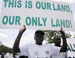
Rhodesia to Zimbabwe: Satellite photos show damage done to the country by seizing White farms
(005875.811-:E-000062.43:N-AC:R-SU:C-30:V)
[Here’s another article by an economist showing that so-called “Land Reform” (actually just seizing the white farms in Zimbabwe), did actual damage to the countryside. I remember posting other satellite pics on AfricanCrisis a long time back. But as you can see, it can be studied. This is also from 2006, though Mugabe had by then not finished destroying the farms. Jan]
Scorched Earth in Zimbabwe: Before and After Satellite Photos
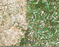
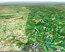
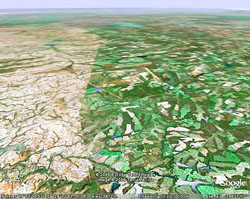
Land reform begun in Zimbabwe in 2000 was supposed to redistribute land from predominantly white-owned commercial farms to much poorer black farmers who toiled on communal lands. Proponents argued that the redistribution was necessary because commercial farms occupied the most fertile lands, leaving only dry, dusty land for communal use. This rationale reflects confusion about cause and effect regarding land ownership and land quality. In the “Before” photo below, the dry communal lands on the left are sharply delineated from the green private farms dotted with lakes and ponds on the right–so sharply that soil quality and rainfall are unlikely to explain the difference. Now click the arrow to see what happened after land reform. The dams and irrigation systems on the private farms collapsed, making them look more like communal lands, to the detriment of all.
Before Land Reform |
After Land Reform |
 |
 |
 |
 |
Context
Zimbabwe is one of Sub-Saharan Africa’s bleakest cases. Under an increasingly oppressive regime led by Robert Mugabe since 1980, Zimbabwe has been marked by massive human displacement, run-away inflation, and a plummeting economy. The before and after satellite photos were prepared by Craig J. Richardson, a Salem College economist, using Google Earth, a powerful new software tool that pools images from various satellite imaging companies. The photos presented were taken over the province of Mashonaland West, which has some of Zimbabwe’s richest soil. The photos provide graphic new evidence of the environmental, economic and social costs of ill-conceived land reform. The photos are presented as part of a Center for Global Development initiative: Zimbabwe: Crisis and Future which provides analysis of the economic conditions and proposes ways for the international community to think about its supporting role in the upcoming transition to a post-Mugabe Zimbabwe.
The three commentaries below explore such topics as how land tenure has affected land use patterns, how the revocation of property rights impacted agricultural productivity, and what these changes mean for Zimbabwe’s future.
Source: https://www.cgdev.org/page/scorched-earth-zimbabwe-and-after-satellite-photos
About the Photos
These before and after satellite photos were created by Craig J. Richardson, a Salem College economist, using Google Earth, a powerful new software tool that pools images from various satellite imaging companies. The farm photos presented here were taken in the province of Mashonaland West which possesses some of the richest soil in Zimbabwe. The exact location of the farms is shown by the pushpin icon on the country photo. The bottom of the photos lists the exact location coordinates, as well as the altitude. The photos are also time-stamped “2005” and “2006”. Because the photos are updated on a rolling basis, it is impossible to know the exact date they were taken. According to Google, the “2005” pictures could have been taken anytime between 2003 and 2005. The 2006 photos were posted about three months ago, meaning they were taken in the first quarter of 2006 and are thus fairly close to the farmlands’ current state.
Between the two photos, rainfall has been reported to be “average to above average” according to FEWS.net, the Famine Early Warning Systems Network of USAID. This means that drought does not explain the recent drying up of thousands of reservoirs as well as the farmland.
*Google releases the rights of these images for non-commercial purposes only. Scroll through the images below to see the stark differences in the land before and after land reforms.
Before Land Reform |
After Land Reform |
 |
 |
 |
 |
Full Country View
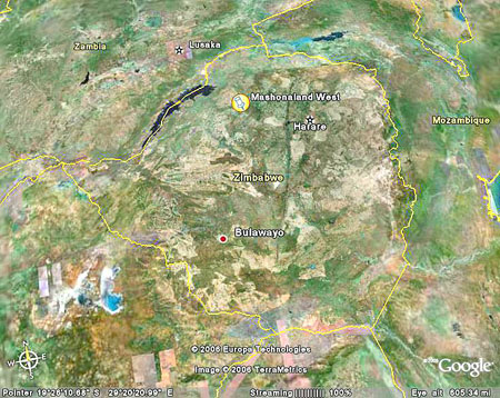
Source: https://www.cgdev.org/page/about-photos
Video: WTA02: NATOs Secret Wars: How Portugal fought Blacks in Africa with NATO and US help
This video also contains the fabulous story of how and why West Germany was quickly admitted into NATO after WW2. In here you will see how different European nations are, compared to America and weak Britain.
Video: Tom Metzger & Jan: Jews infiltrate White thinking and also the NAZI Rockwell
We discuss how Tom got into politics and how he began to understand the Jewish problem. So we focus on the events of the 1960s. Tom worked as a TV Technician and later worked for Douglas aircraft.
Afrikaanse Boeke op AfricanCrisis
Hier is ‘n paar boeke wat jy nie in gewone liberale winkels sal kry nie!

